Geoprospection Survey & G.I.S.
Introduction
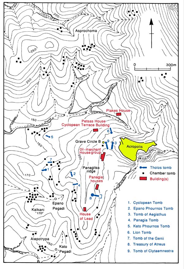
Ever since the commencement of the archaeological investigation of Mycenae by Heinrich Schliemann in 1874, excavators have focused mainly on the citadel and the palace itself, whereas fieldwork outside the walls has been limited to cemeteries stretching farther on the hill slopes around Mycenae (Grave Circle B, three groups of nine tholos tombs, and chamber tombs at Panagia, Kalkani, Epano and Kato Pegadi, Alepotrypa, Kapsala, Asprochoma), and to few buildings of the settlement once surrounding the citadel (Oil-Merchant complex, Panagia group, House of Lead; House of the Wine Merchant and Cyclopean Terrace Building, Petsas House, Plakes House). Although some of these structures are clearly domestic units (Panagia group), others appear to have been a combination of residential areas, storerooms, and workshops, which are plausibly interpreted as palatial buildings and annexes connected with palatial economy, bureaucracy and administration (Oil-Merchant complex).
Surface Survey
In 1991-1993 an extensive archaeological survey was jointly conducted by the Athens Archaeological Society and the British School at Athens which located, identified and mapped all visible remains throughout the wider area of Mycenae (32 hectares), including more than 750 sites, structures, buildings, guard towers, beacons, wall remains, tombs, roads, and bridges. The survey retraced the extensive network of roads and highways in the area of Mycenae and established its spatial association with the location of the surrounding cemeteries.
Aerial Reconnaissance
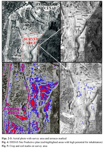
The software-enhanced analysis of high-resolution aerial photographs of the area around Mycenae, taken in the spring of 1988 and kindly supplied by the Greek Military Geographical Service (G.Y.S.), revealed upon careful inspection distinct “ghost traces” of walls as crop/soil marks on terraces SEB I and SWB I-V of the targeted area. These aerial photographs of Mycenae were also used in conjunction with a silo-locating military program (ERDAS Imagine 8.4) which compares visible, recognizable features within the photograph to other features that match the set parameters in order to produce the resulting image of a site prediction model. It was, therefore, possible to determine and confirm plausible locations to conduct the geoprospection survey. The areas in red are the most interesting because they pick up likely features in the very same locations targeted by the archaeological survey and highlighted on the aerial photograph as producing ghost traces (SEB I, SWB I-VII): these areas were finally selected as being most likely to produce promising remote-sensing results and physical remains by excavation.
Geoprospection Survey
In 2003 a systematic geophysical prospection and remote-sensing survey was launched at Mycenae under the auspices of the Athens Archaeological Society, and with the generous funding and technical support of Dickinson College and the Institute for Aegean Prehistory (INSTAP). Several ground-based remote-sensing methods (including Ground Penetrating Radar, Magnetometry, Electrical Resistivity) are being combined to map all visible and buried structures in the area around the citadel, to locate buildings, sectors and roads of the settlement of Mycenae outside the walls, and ultimately to create a 3-D digital model of the buried Lower Town of Mycenae. Plotting and mapping of the survey grids is carried out by means of GPS and Total Station; the survey data, the geomorphology of the study area, the archaeological remains and topographical parameters are being integrated in a GIS model. The preliminary survey data outline mainly two superimposed occupation levels at two different depth ranges (0.40–1m and 1.20–2m) which are further set apart by the distinct types, size, and orientation of their structures: a small Geometric/Archaic settlement and an underlying, large Mycenaean town (ca. 30 hectares), the latter arguably consisting of domestic units and commercial buildings, but also including larger complexes potentially connected with palatial economy, bureaucracy and administration.
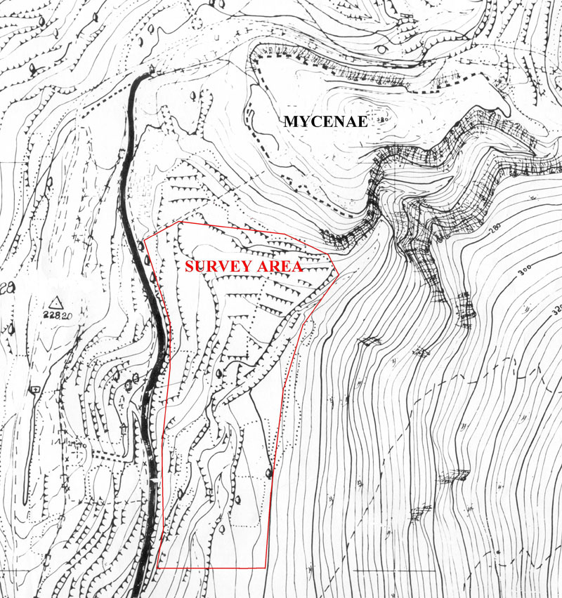
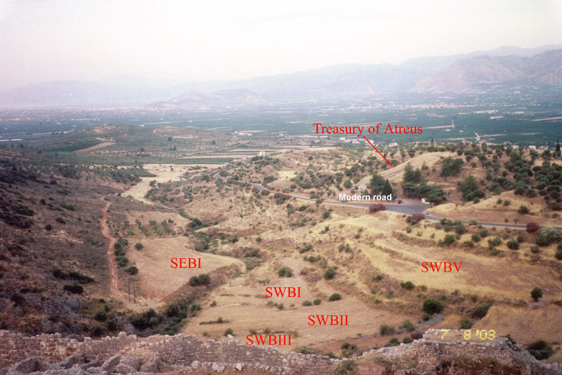
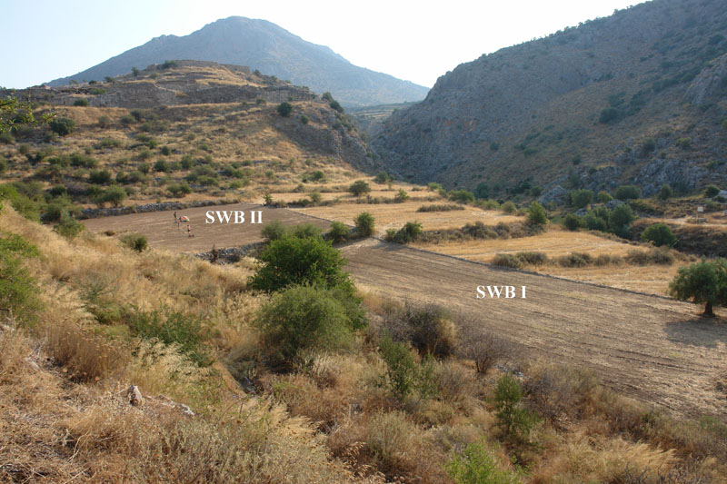
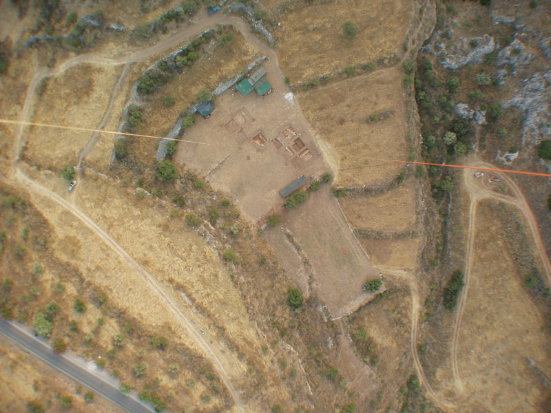
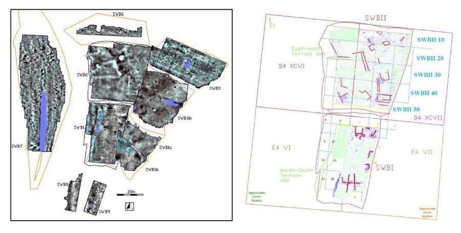
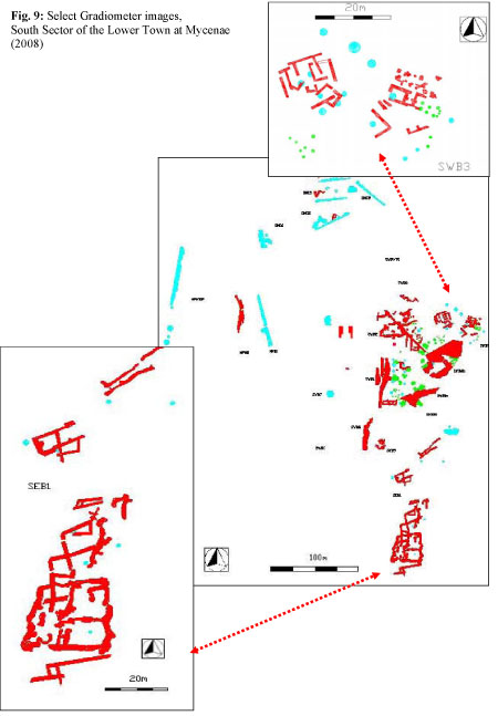
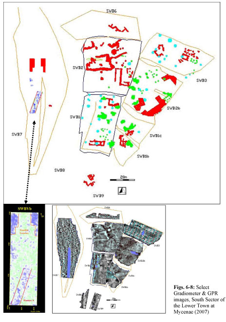
The systematic geoprospection survey of the Lower Town at Mycenae has mainly targeted the terraced fields flanking the dry riverbed gorge of Chavos in the area south of the citadel. The terraces, which are retained and delineated by modern low, stone-built walls, were named after their location in regard to the riverbed: South East Bank (SEB), South West Bank (SWB) I-VII. The survey area was selected after careful examination of the local geomorphology (artificially terraced land, thick undisturbed fill, sealed and protected by successive river alluvium deposits) and consideration of several topographical and archaeological variables: the spatial distribution and orientation of visible ruins; the alignment of the east façade of the Oil-Merchant complex and the Panagia group which may indicate the presence of a northbound highway leading to the Lion Gate, running almost parallel to and east of the modern road, to which the orientation of both building groups possibly conformed; the existence of at least two Mycenaean bridges over the Chavos river further south, connecting the two river banks and their respective terraces; the discovery of scant remains of a Cyclopean retaining wall running along the eastern edge of terraces SWB II-IV on the western bank of Chavos; the distinct pattern of successive artificial terraces which was widely used on the hill slopes around Mycenae for palatial and residential or commercial buildings, built on terraces and supported by thick retaining walls on the down slope; and finally, the quantity and types of chance finds during the clearing of the fields, including mainly Mycenaean sherds, stone tools, and figurines, mixed with a few Hellenistic sherds and loom weights, which indicate a strong presence of Mycenaean and later domestic contexts.
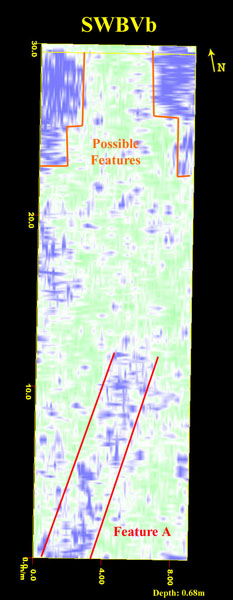
In the period of 2003-2008 a total of c.50 grids were surveyed with Ground Penetrating Radar, Fluxgate Gradiometer, and Electrometer on seven separate terraces on both banks, with most interesting results so far. Many structures were traced, identified and mapped, including a megaron and a large structure (SWB II), two large buildings (SWB III) and an immense, multi-room compound (SEB I). The geoprospection survey also located roads and extant parts of an outer fortification wall (5m thick) with at least two and possibly three gates. The central gate is framed by two Γ-shaped gate towers (at least 3.5m wide, preserved to a total height of approximately 1m at a depth of –0.68m) and controls the main northbound highway (3m wide) which runs N–S (roughly parallel to the modern road) leading up to the citadel through the settlement. A strikingly similar a structure located at the extreme edge of the Panagitsa hill and labeled by Steffen in 1884 as a gate, consisting of two terrace-like buildings set approximately 6m apart and framing a possible roadway. A third, eastern gate and part of the impressive 5m-thick outer fortification wall were further traced by the gradiometer on terrace SWB IIb by the western bank of Chavos, which is connected perhaps with a retaining wall along the western bank and the remains of at least one Mycenaean bridge/dam (as indicated by deep cuttings on the bedrock). The possibility of a bridge/dam in the Chavos gorge near the eastern gate and arguably of a small artificial lake at the mouth of the gorge will be further investigated by drilling deep core samples and micromorphological analysis of the sediment. The geoprospection survey facilitates the selection of targets for future excavation and the integration of unexcavated areas into the overall topographical map and archaeological plan of the settlement. The preliminary study of these impressive finds has led to the purchase of six more stremmata of land (1.5 acres) which will further expand and unify the archaeological site of Mycenae.
Preliminary Conclusions
Did a ‘Lower Town' exist at Mycenae? The lack of sufficient evidence for street layouts dividing blocks of structures linked by integrated drainage systems, and the discovery of scattered, isolated building groups of both palatial and residential use, oddly intermingled with tholos tombs and served by separate drain systems, have generated the theory that there was no town around Mycenae in the form of a sizeable urban center with organized closed poleodomic plan; instead, it has been theorized that the citadel of Mycenae was surrounded by several loosely connected small settlements, each with its own cemetery, which must have gradually expanded from original nuclei in an additive open plan and eventually framed the highways and roads leading to Mycenae without obeying to a prior closed town plan. The alleged absence of large-scale urbanization has been repeatedly hypothesized for Mycenae and other Mycenaean centers; such views were apparently fueled by the lack of sufficiently extensive excavations of settlements on mainland Greece –most of which range from small towns to villages and farmsteads– and especially of the sites surrounding the main palaces and citadels of Mycenae, Tiryns, Pylos, Thebes, Orchomenos, and Athens. This picture, though, is at variance with the textual evidence from the Linear B tablets regarding Mycenaean political geography and administration (e.g. the recorded administrative provinces, districts, and towns of the Pylos state), and socioeconomic organization of the Mycenaean states. In recent years intensive and extensive regional surveys on the mainland have produced important spatial analysis of settlement patterns which further define the diachronic development of settlements and trace synchronic regional patterns of uniformity and variation; meanwhile, renewed excavation at palatial sites and their surrounding areas (Mycenae, Tiryns, Thebes, Pylos) and systematic extensive excavation of several Mycenaean settlements, combined with the textual evidence and regional survey data, reveal emerging settlement patterns consistent with varying degrees of localized urbanization.
The number, size, type, and spatial distribution of the extant features, structures, and buildings traced thus far by the ground-based remote-sensing survey seem to support the possibility of a sizable urban center surrounding the citadel on the west, south, and north sides: this town may have extended over an area of ca. 30 hectares (with a normal population density of 200 people per hectare), consisting mainly of domestic units and commercial buildings, but also including larger palatial structures and annexes (workshops, offices, storerooms) located closer to the main access roads and highways. The potential discovery of the main gate, once associated perhaps with an outer circuit wall, further reinforces the possibility of an organized town plan; to this conclusion point also definite town boundary markers that appear to have been in place already by the late 14th century B.C. The discovered buildings outside the walls belong to either of two types, the long corridor plan with two levels following the platform line of its terrace, and the square version with rooms arranged around a central court; both types as well as two more types (the megaron type and parallel oblong storerooms) have been identified in the radar images on the south, terraced slope. Furthermore, it appears that although the palatial annexes outside the walls were destroyed by earthquake and fire in LH IIIB1/2 (ca. 1240 B.C.) and were subsequently abandoned, several residential buildings were repaired and continued to be in use well into the LH IIIB2/C period along with a number of chamber tombs, a pattern which is consistent with the composition of a town.
The comparative study of the spatial distribution of chamber tomb cemeteries, grave circles and tholos tombs may explain the alleged 'odd' intermingling of houses and tombs: the royal Grave Circle B which was founded at the western end of an extensive MH cemetery stretching from Grave Circle A to the west of the Mycenae hill, was originally lying outside the contemporary MH settlement on the hill; later on, one group of royal tholos tombs (Aegisthus, Lion, and Clytaemnestra Tombs) were gradually built in the area of this earlier cemetery, close to the ancestral royal graves, and occupying the prominent location at the crossroads of the highways leading up to the citadel's main gate, which secured visibility. Meanwhile, the expansion of the town of Mycenae outside the walls eventually engulfed this group of tholos tombs and covered all the adjacent hill slopes; for lack of appropriate space, the very last tholos tomb of another group, the Treasury of Atreus, was built amidst houses (Panagia group) facing the northbound highway leading to the citadel. Other than the latter, though, no other tholos tomb or cluster of chamber tombs breaks the unity of the settlement or infiltrates the central town area; in fact, the peripheral spatial distribution of the cemeteries located farther around the citadel and its surrounding settlement demarcates the borders of the settlement itself, thus revealing a site pattern of three successive and concentric occupation zones (palatial, residential, and cemetery).
The final results of this on-going geoprospection survey which will expand on several other areas outside the fortification walls, will be published collectively as a second volume to the Archaeological Atlas of Mycenae, and forms the basis for the systematic excavation of the settlement of Mycenae.


.jpg)