Lower Town
Beyond the Walls of Agamemnon: Excavation of the Mycenae Lower Town (2007-2011)
Introduction
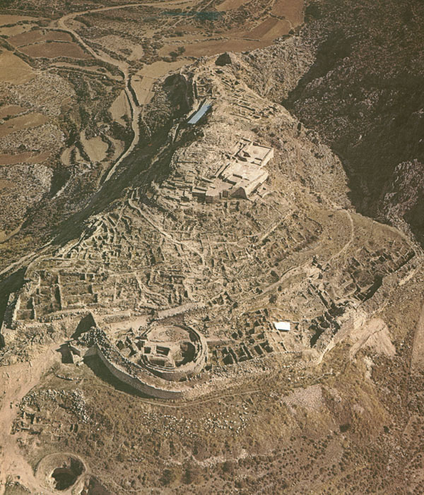
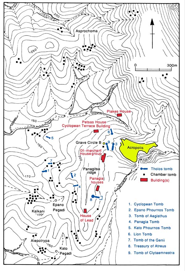
Ever since the commencement of the archaeological investigation of Mycenae by Heinrich Schliemann in 1874, excavators have focused mainly on the citadel and the palace itself, whereas fieldwork outside the walls has been limited to cemeteries stretching farther on the hill slopes around Mycenae, and to few buildings of the settlement once surrounding the citadel (Oil-Merchant complex, Panagia group, House of Lead; House of the Wine Merchant and Cyclopean Terrace Building, Petsas House, Plakes House).
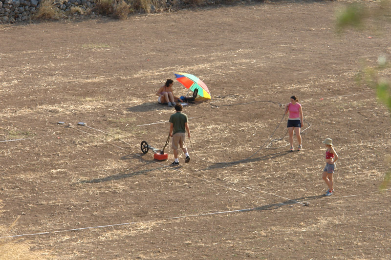
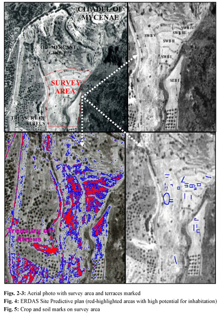
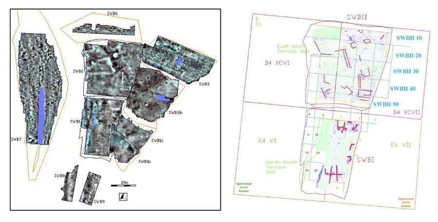
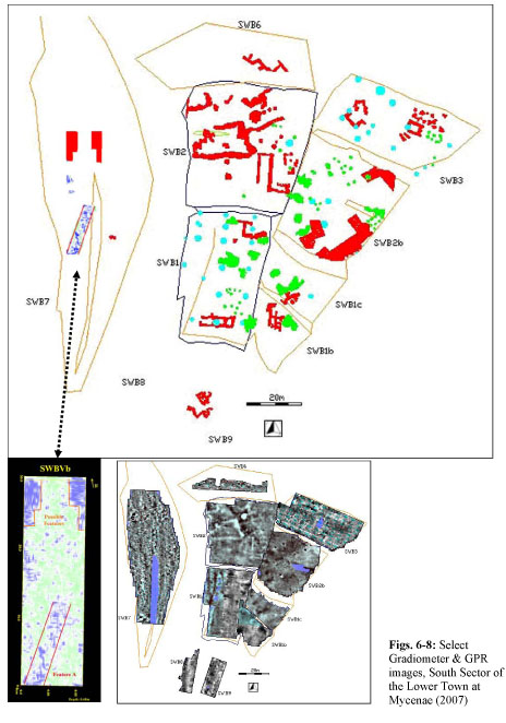
Recently, an extensive surface survey (1991-1993) and a systematic geophysical survey (2003-2009) combining ground-based remote-sensing methods, G.I.S., and aerial reconnaissance discovered, identified and mapped hundreds of visible and buried structures in a wide area around the citadel, including tombs, houses, buildings, guard towers, beacons, a network of roads and highways, bridges and dams, as well as an outer fortification wall with three gates. The preliminary survey data outline mainly two superimposed occupation levels, namely a small Geometric/Archaic settlement and an underlying, large Mycenaean town (ca. 30 hectares) consisting mainly of domestic units and commercial buildings, but also including larger structures potentially connected with palatial economy, bureaucracy and administration.
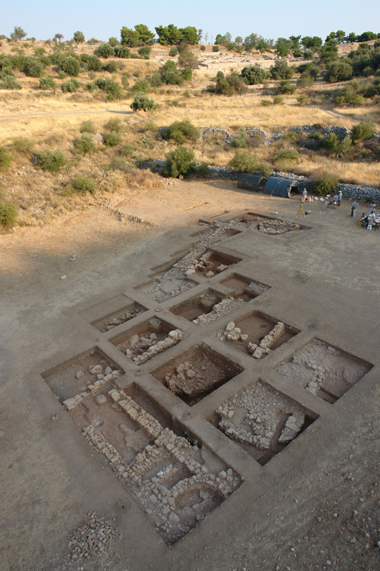
The systematic excavation of the Lower Town at Mycenae (2007-2011) which was planned on the basis of the highly accurate geoprospection images, has already revealed Geometric and Archaic walls and structures, undisturbed Geometric cist-graves, large Mycenaean walls and buildings, and has yielded important finds; furthermore, it has documented the undisturbed stratification and excellent preservation of the substantial Mycenaean ruins (max. pres. height of 1.8m), as they were sealed and protected from later intrusions and activities by a thick, sterile stratum formed by slope erosion.
The geoarchaeological study of the Chavos area and the examination of the geomorphology and stratigraphy of the excavated sector identified two superimposed natural fills which define two distinct stratigraphical and chronological horizons, namely a thick reddish-brown sterile colluvial fill (water flow) and an overlying red fill with fine sedimentation (debris flow). The former emerges at the depth of -2.5m (elevation +215m, D4-XCVII-53/63/64/73) and is characterized by a coarse reddish-brown sedimentation, large deposits of cobbles, stones, and boulders, and complete absence of finds. This sterile colluvial fill was probably formed by recurring overflows and extensive flooding of the Chavos river, as indicated by the depth of sedimentation and the horizontal grading of the deposited material. The course of Chavos, the size of its riverbed, and the surrounding landscape have changed significantly since antiquity due to a combination of natural and cultural formation processes. In antiquity, the riverbed of Chavos must have been considerably shallower and wider beyond the mouth of the gorge formed between Zara and the rocky hill of Mycenae. The river would frequently overflow and flood the flat land south of the citadel, to judge from the depth of sedimentation and the wide distribution of deposited material. The soil micromorphology of this fill reveals traces of ground surface morphogenesis, which means that it must have been exposed to the elements and subject to severe weathering for a prolonged period of time before it was gradually covered by various structures in the Mycenaean period and eventually filled in from slope erosion and debris flow in the post-Mycenaean years. In the late Mycenaean period (LH IIIA/B?) a strong retaining wall was built alongside the western bank of Chavos following its N-S orientation (SWB Ic, IIb, III) in order to delineate and narrow down the riverbed, contain the river flow, protect the adjacent flat land to the west from recurring overflows and flood, and allow the spatial re-organization of landscape to facilitate the expansion of the south sector of the Lower Town. The foundation of this retaining wall lies 2m higher (elevation +217m) than the horizon of the reddish-brown natural fill in the excavated sector; this considerable elevation difference illustrates vividly the urgent need to protect the area from flooding. The Chavos river was successfully contained, as documented by the deposition of finer sedimentation in later fills and the absence of rocks and boulders therein, the spatial re-organization of the surrounding landscape and its subsequent modification for domestic and industrial use. The narrowing of the riverbed, however, increased the river current, which consequently caused a gradual deepening of the riverbed. The strong water flow was controlled by a series of Mycenaean water dams which created an artificial pond at the mouth of the gorge securing water supply for the settlement and adequate field irrigation. All these hydrologic modifications and their relative environmental impact aimed at a drastic transformation and spatial re-organization of the surrounding landscape, thus serving a systematic modification of farmland to domestic, industrial, and burial space.
The decline of Mycenae and gradual abandonment or destruction of the Mycenaean engineering projects (terraces, retaining walls, dams) in the early post-Mycenaean period resulted in the gradual accumulation of a natural red fill, a buildup of soil caused by slope erosion and flooding over a long period of time (debris flow). The geoarchaeological study of the stratigraphy in a deep test pit (D4-XCVII-64) traced another ancient torrent riverbed which is clearly recorded in the geoprospection images as a wide black streak crossing diagonally the terraced fields to the southeast. The depth of sedimentation and the horizontal grading of the deposited material indicate that the torrent flow was strong and recurring with a NW-SE orientation from the slopes of the citadel towards the Chavos riverbed where its outlet was traced. This natural fill upon which (or cutting therein) the Geometric and Archaic structures were founded, emerges at the same depth in the trenches of the excavated sector; therefore, the red fill defines a naturally formed stratigraphical and chronological horizon which seals, protects, and separates the underlying Mycenaean structures and contexts from the overlying superimposed Geometric and Archaic layers, thus connecting the excavated contexts and unifying the stratification of the whole site. Systematic geoelectrical prospection combined with targeted deep-core drilling and soil micromorphology will further define the paleogeomorphology of the area, trace the original course, width and depth of the Chavos riverbed, and detect ancient hydrologic, landscape, and environmental changes.
Excavation
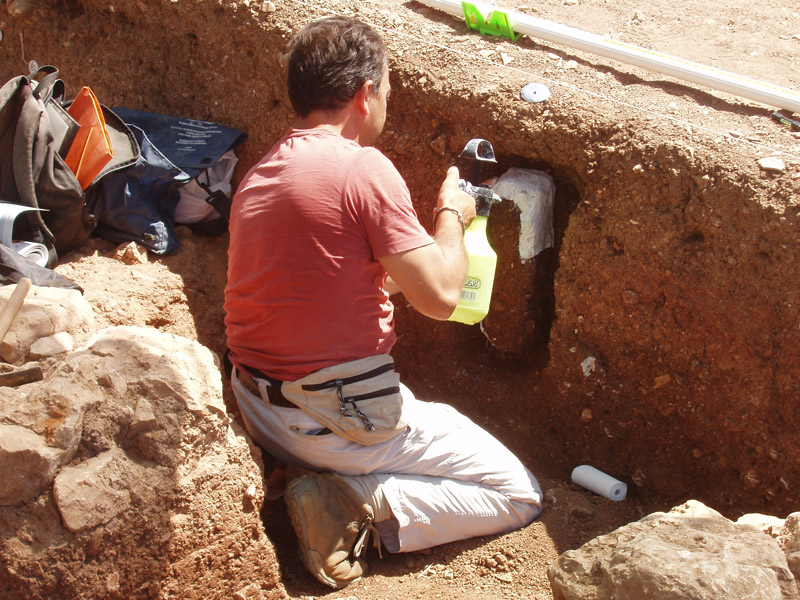
The systematic excavation of the Lower Town at Mycenae (2007-2011) is conducted under the auspices of the Athens Archaeological Society and with the generous funding and technical support of Dickinson College and the INSTAP.
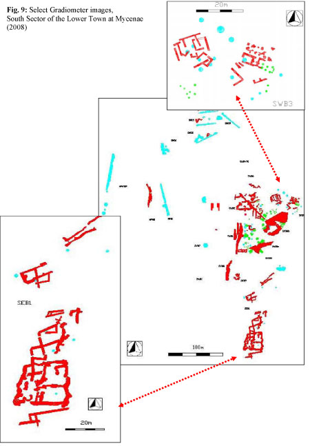
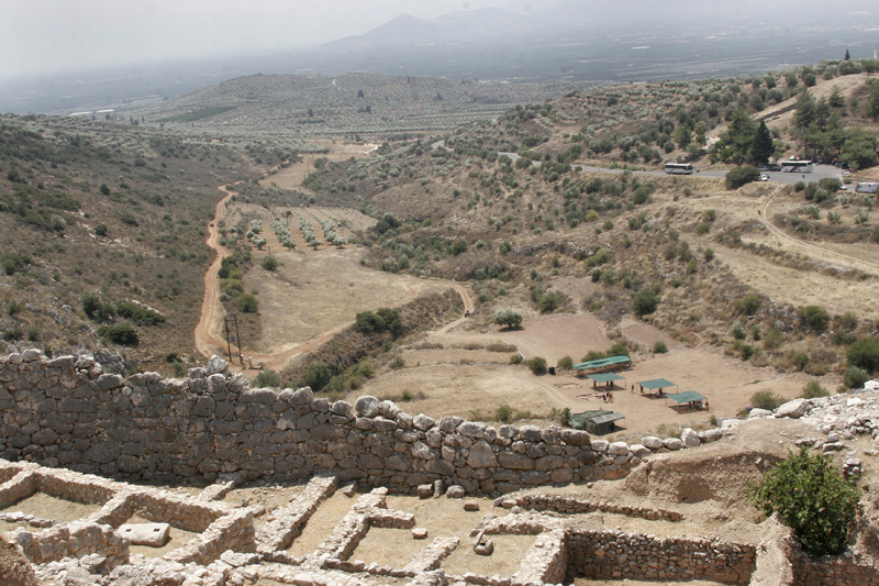
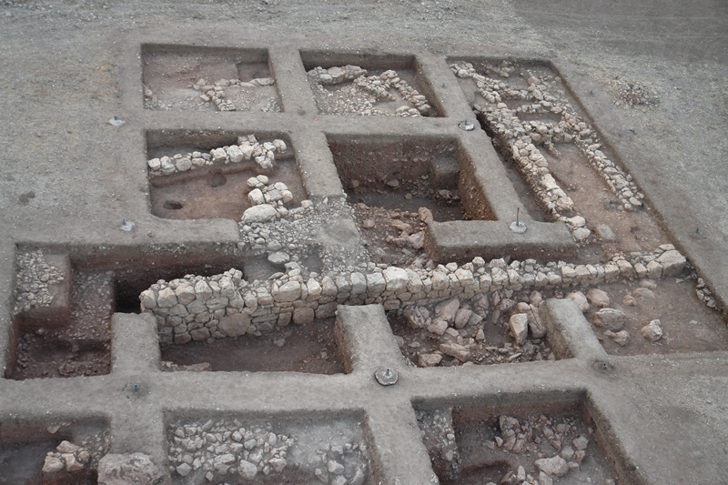
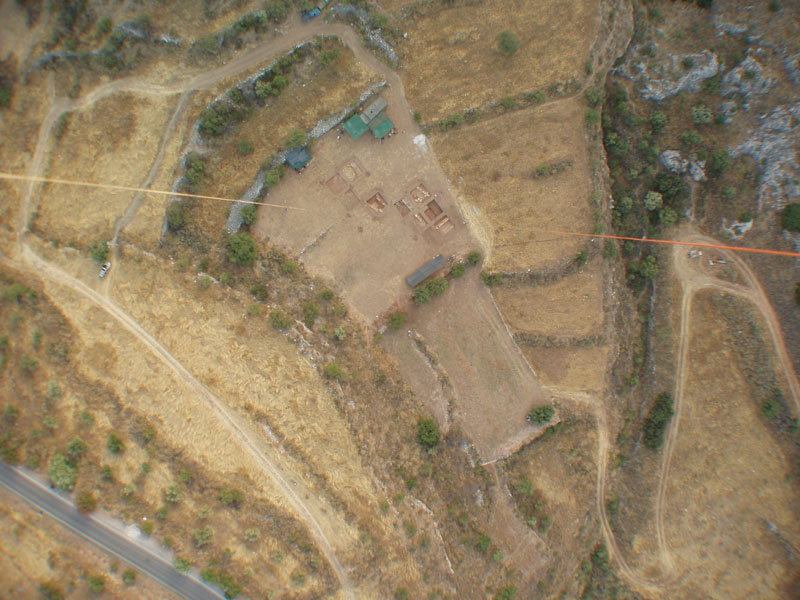
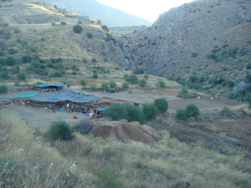
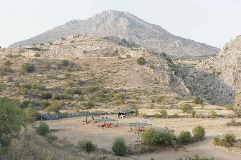
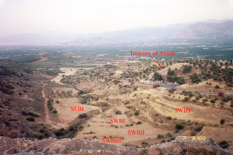
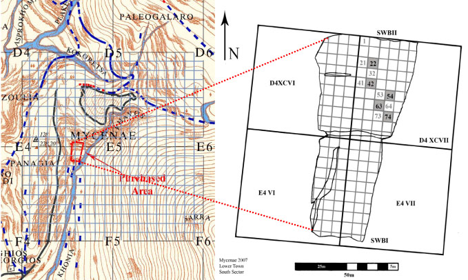
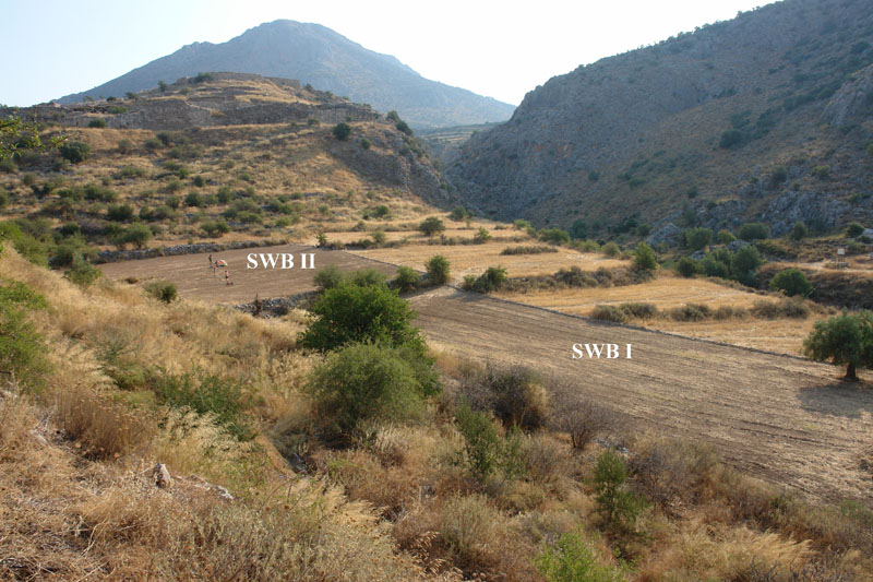
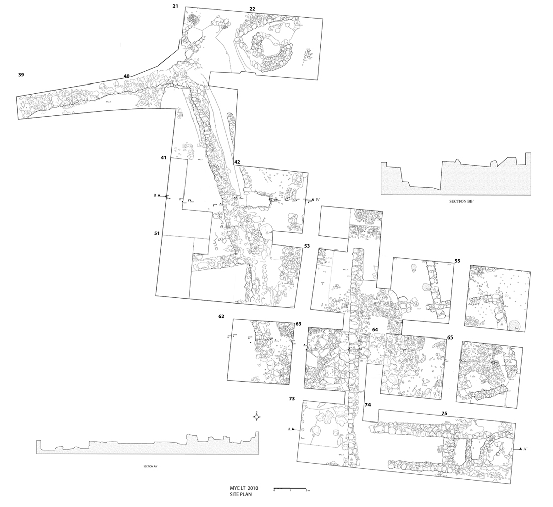
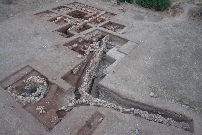
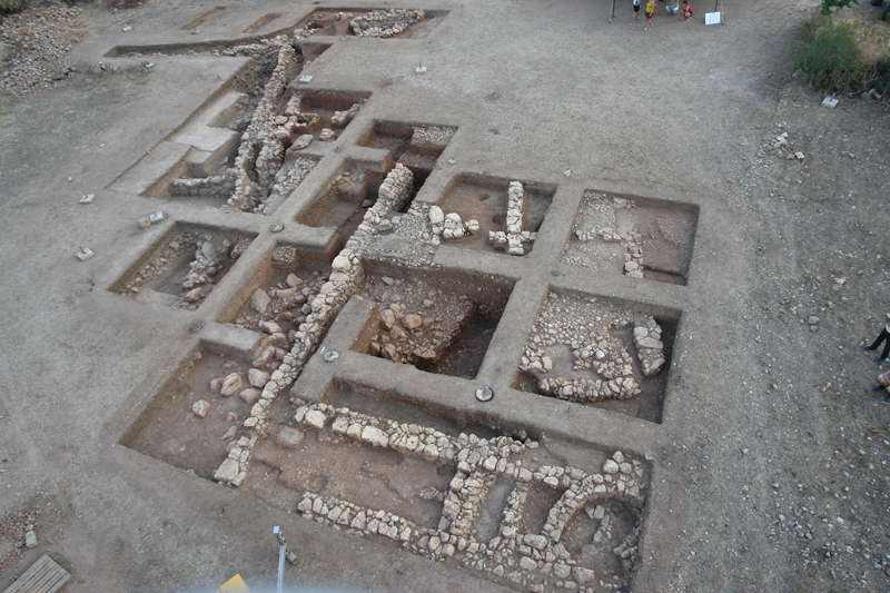
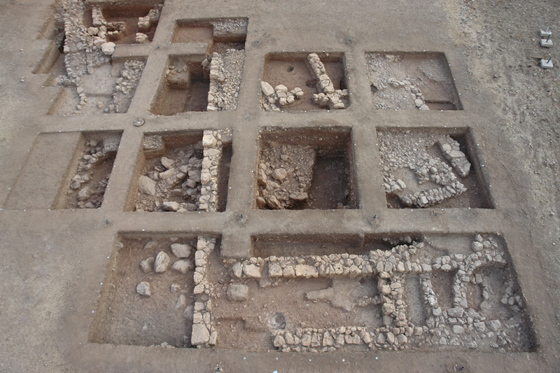
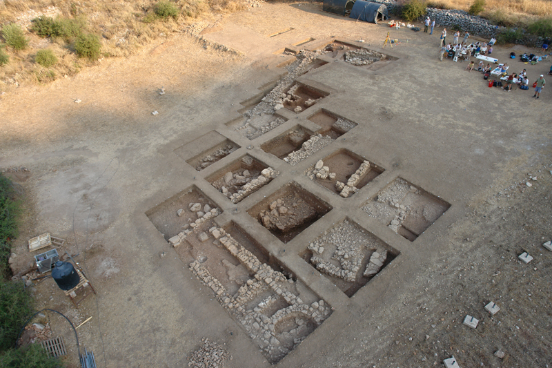
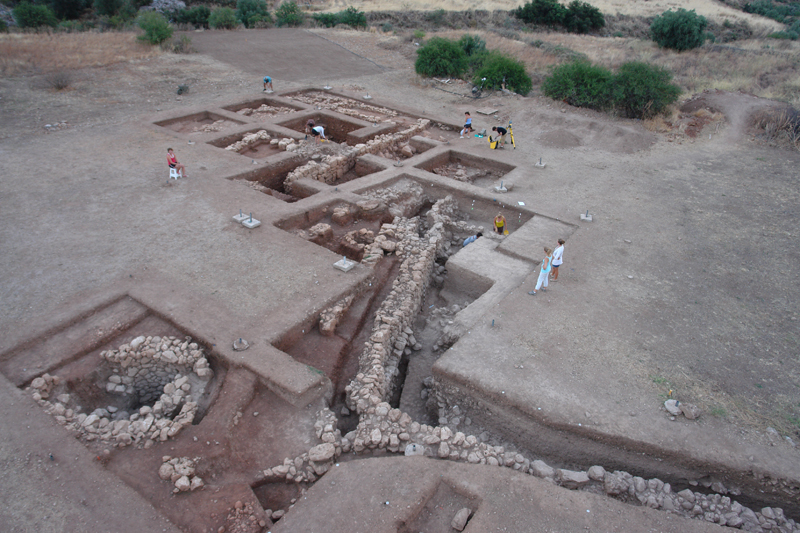
The excavation of the settlement focused initially on the South Sector, and more specifically on the western part of terraces I and II of the South-West Bank (SWB I, II), where four stremmata (1 acre) of the surveyed land were purchased in 2006 with funds from Dickinson College. In the topographical grid of Mycenae, the purchased land falls within grid-squares D4 and E4 (500×500m), each of which was divided into 50x50m grid-squares (numbered in Roman numerals I-C); each of those, in turn, was further sub-divided into 5x5m grid-squares (1-100), and finally into 1x1m grid-squares (e.g. D4-XCVIΙ-22-2a). The geodetic measurement and plotting of the topographical and archaeological grids was carried out by means of Total Station. All the field campaigns so far (2007-2011) have targeted the northern part of the purchased land (SWB II), where the intensive geophysical survey identified and located with remarkable precision substantial structures to a depth of -2.5m; these include houses, workshops, building complexes, and an outer fortification wall (5m thick) with at least two gates, one of which is framed by two gate towers and controls the main northbound highway (3m wide) which runs N–S (roughly parallel to the modern road) leading up to the citadel through the settlement. In general, architectural features and structures of the settlement at Mycenae emerge at the depth of only -0.10/0.15m. Their lay-out and spatial distribution reveal different orientation patterns of chronological significance: Mycenaean buildings follow a N-S orientation, parallel to the main northbound road to the citadel, whereas later structures appear to be oriented NW-SE . In particular, twenty-one 5×5m grid squares have been excavated so far (D4-XCVI-38, 39, 40 and D4-XCVIΙ-21, 22, 31, 41, 42, 43, 51, 52, 53, 54, 55, 62, 63, 64, 65, 73, 74, 75) .
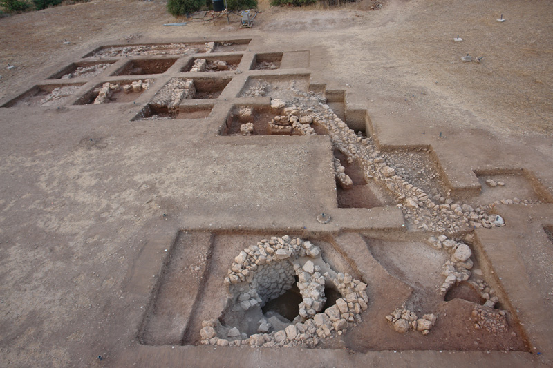
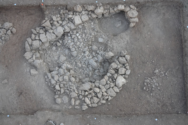
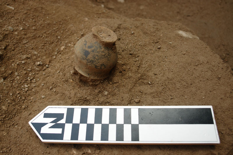
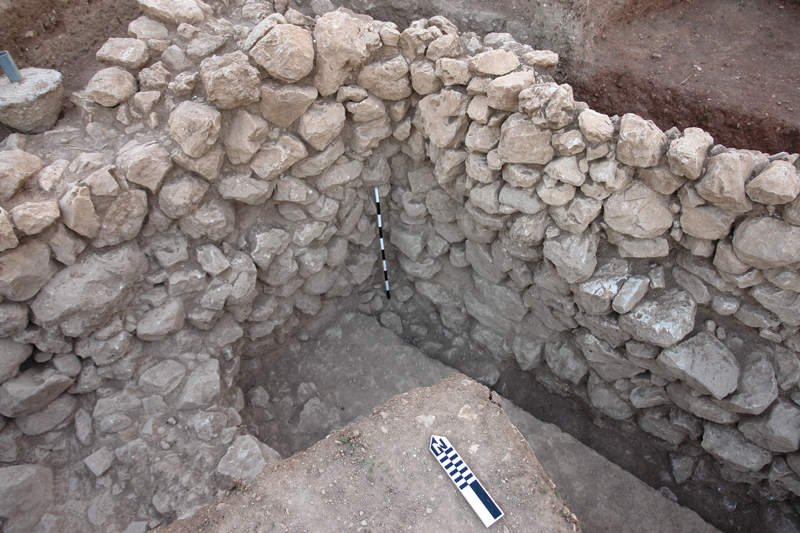
In the northwestern part of the SWB II terrace, precisely where the fluxgate gradiometer and the GPR had detected a fan-shaped feature (D4-XCVI Ι -21/22), a peculiar apsidal structure (3.20m x 4m) which progressively narrows and funnels downwards was discovered. Two architectural phases can be discerned in the construction of the structure which appears to have been originally circular and subsequently apsidal, as its northern half was severed and the structure was expanded northward with the addition of a straight wall with rounded ends and an entrance possibly on the northeast. The 0.75m-thick curved wall of the structure is built of two faces with medium-sized field stones and rubble core fill. The interior face of the curved wall tapers down to a depth of at least ten courses, whereas its exterior face was unearthed to a height of only three courses, for traces of a walking surface were detected around the curved wall on that level. The interior of the apsidal structure was covered with a thick destruction fill containing a rubble pile of fallen stones, melted mud-brick, ‘plesia' (insulating whitish mortar), floor slabs, and terracotta roof tiles. The destruction fill sealed an underlying thin pebble layer (floor?) which was laid upon a deep sandy silt fill containing very few finds so far, including a black-glazed single-handled miniature cup (kyathion). The pottery collected so far from the interior of the structure is predominantly Mycenaean, but also includes very few Middle Helladic sherds, Geometric and Archaic pottery, and a few red-glazed and black-glazed Hellenistic pottery sherds and fragments of roof tiles. The stratification and horizontal grading of the fill deposit from larger to finer material (medium-sized stones, small stones, pebbles, fine sandy/silt sediment) and the wet silt fill indicate presence of stagnant water and gradual sedimentation of material in the interior of the structure. The precise function, however, of the apsidal structure still remains elusive: formerly it was tentatively identified as a ceramic kiln on the basis of its apsidal ground-plan, its strong magnetic image, and the discovery of a few misfired sherds in the vicinity; the fill sedimentation, though, combined with the downward tapering and increasing depth of the structure rather seem to support a tentative identification of a cistern, bothros, or well.
An open-air hearth encased by a two-course-high circular rubble wall was discovered west of the apsidal structure. The hearth was marked by strong fire traces and produced remains of charcoal and burnt animal bones. Scattered around the hearth were found carbonized organic remains (olive pits), Mycenaean figurines and sherds (including the spout of a stirrup jar), clay vase lids and corks, a small clay disc (possibly potter's wheel?), but also a few Middle Helladic (Minyan), Geometric and Archaic sherds (including a diagnostic 6 th -century-BC Corinthian sherd decorated with a panther and filling ornaments).
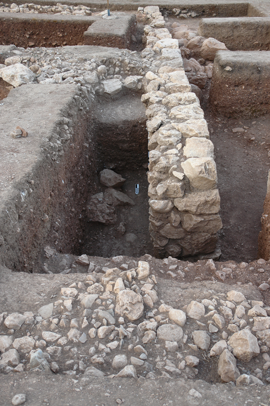
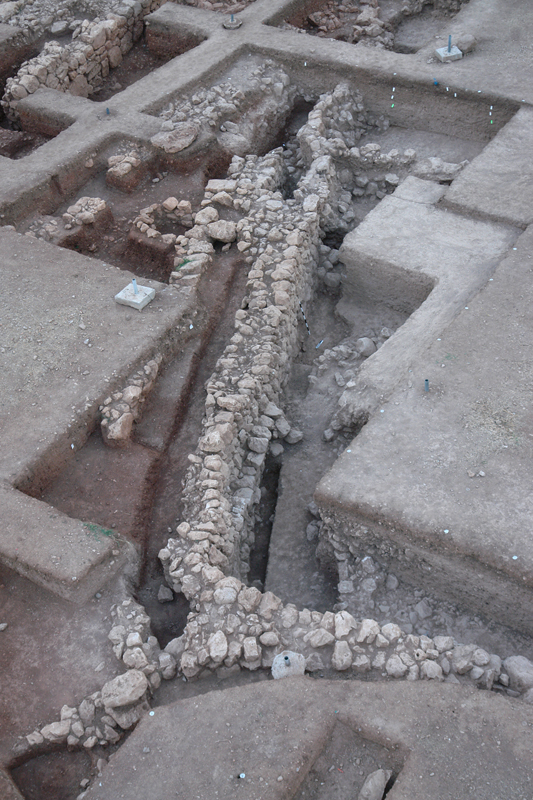
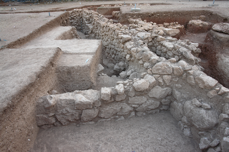
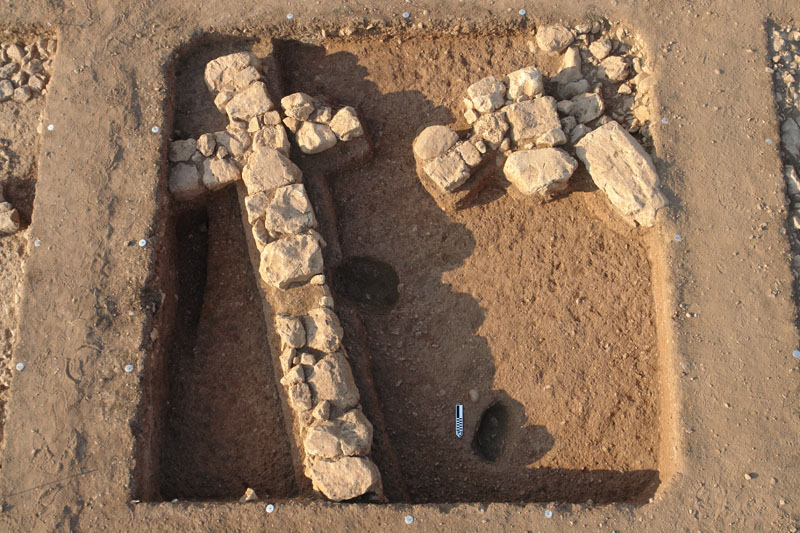
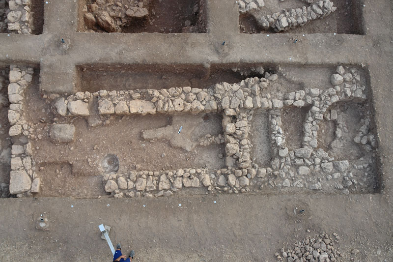
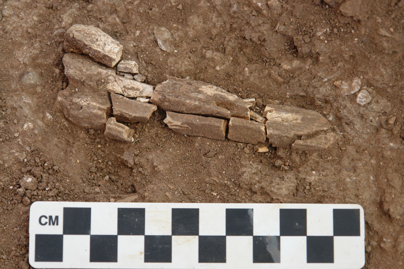
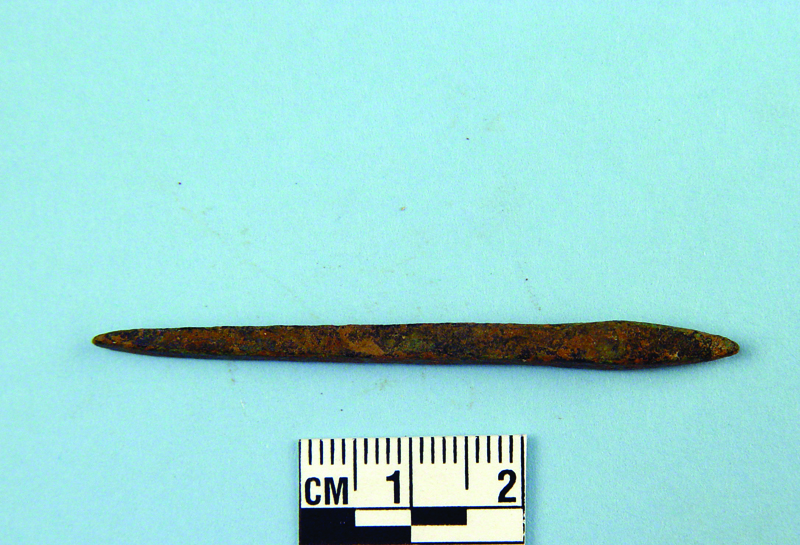
In the western sector of the excavated area (D4-XCVI-38/39/40; D4-XCVII-21/31/41/42/51/52/62), a long and solid wall (Wall B) runs SE-NW for some 20m before turning to the SW at a right angle to run for at least 12m, matching perfectly its trace on the geoprospection images. The westbound section of the wall was revealed to the depth of only three to four courses on its better preserved south face; nevertheless, the wall appears to continue deeper, as indicated by the depth of its fill and the sporadic use of large boulders in its lower courses. This wall may also be connected with the adjacent apsidal structure and the built hearth to the NE, if it does continue eastward, as suggested by the increased thickness at its corner and sporadic wall remains(?) on its projected course to the NE. The finds from the upper fill of the westbound wall are rather mixed, including Mycenaean and Geometric pottery, Mycenaean figurines, an Archaic phiale and figurine, stone tools, a lentoid seal stone bearing the relief image of a schematic female body, an inscribed roof tile, coins, stamped clay spools and lids, iron nails and chisel. The central section of Wall B survives to the height of 2.2m with nine courses on its better preserved western face and thickness that varies considerably (0.60-1m thick). The wall was built of medium-sized field stones and founded upon the reddish-brown fill (water flow) but below the horizon of the red fill (debris flow) which it retains on its eastern side. In the middle of its surviving length the wall forms a well-built eastward indentation on which a Middle Geometric cist grave abuts.
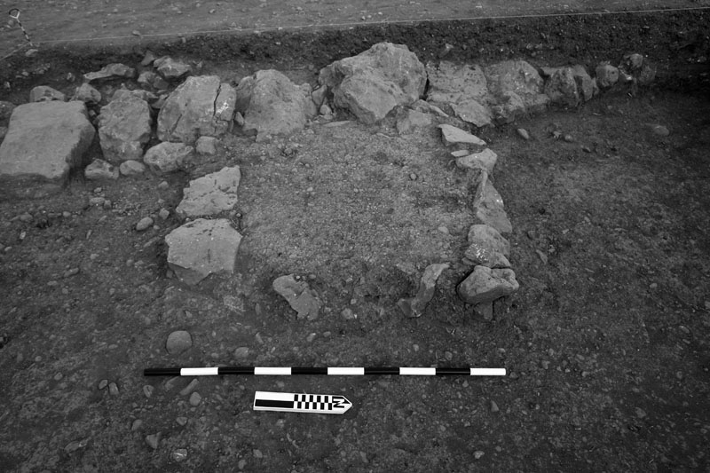
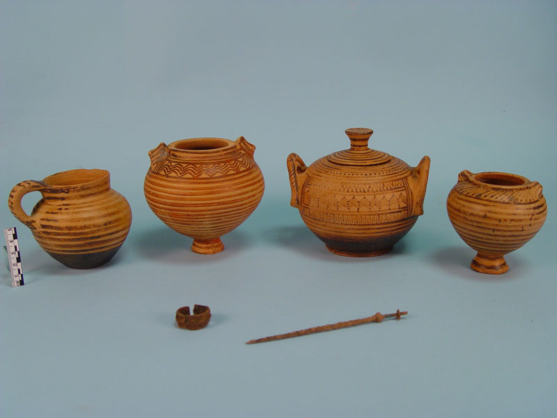
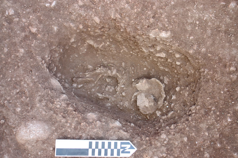
Attached to the eastern face of this wall was found a low, semi-circular or rectangular structure (0.85-1.12m×1.12-1.23m) which is made of packed cobbled fill encased within a two-course-high rubble wall (D4-XCVI Ι -42). At first, this structure was tentatively interpreted as a low, work platform, intended perhaps for food preparation, as indicated by its form, location, and related finds (a clay frying-pan, a pestle, burned animal bones, charcoal, and carbonized organic remains such as grains and seeds) which were discovered in close proximity to the platform. Further investigation, however, of this structure established that this rubble structure was deeper, cutting into the red fill (debris flow) which seals, protects, and separates the underlying Mycenaean stratum from later remains. The excavation of this structure revealed a rectangular, rubble-built cist grave (int. dim. 1.75-1.80m×0.75-0.95m) of E-W orientation, whose western end had been damaged and dismantled during the foundation of a superimposed later wall. The cist grave which was found practically undisturbed, contained a single adult burial interred in a contracted position, resting on its right side with the head oriented westwards and facing south. The articulated skeleton was well-furnished with an iron pin (found in situ on the right shoulder-blade), an iron ring (found in situ around a phalanx of the right hand), and five clay vases, four of which were carefully lined behind the back of the body (two decorated small footed jars with perforated lug-handles, a shattered, undecorated small pithoid vase, and a decorated pyxis with lid), while a fifth one (a decorated one-handled cup) was placed in front of the body and beside the right hand. All the vases but one were found intact and their undisturbed content was sampled for organic residue analysis. The cist grave is securely dated to the late 9 th century B.C. on the basis of Middle Geometric Argive pottery and jewelry found in its context, which also establishes a solid terminus ante quem for the construction and use of Wall B. It appears that the cist grave was backfilled right after the interment with the same soil that was dug out for its construction; that would explain the discovery of several Mycenaean sherds and fragments of Mycenaean figurines in the upper part of its fill. The geomagnetic trace of this grave on the geoprospection images is potentially diagnostic of other Geometric graves in the vicinity, where the south part of Geometric cemetery of Mycenae must have extended.
The area west of Wall B appears to contain stratified Mycenaean and Geometric contexts with very limited infiltration of the red fill. The upper fill yielded mixed pottery (Mycenaean to Archaic) and small finds (lead weights and sheet, coins, iron nails and chisel, clay loom weights and spools) down to the level of a cobbled surface overlying a thick stone pile (D4-XCVII-31). Deeper fills, however, contained Mycenaean and Geometric pottery, Mycenaean buttons and figurines, stone tools (querns, scrapers, obsidian blades), and an unfinished lentoid seal stone. A test pit dug alongside the western face of the wall (D4-XCVII-31/41/51) revealed part of the foundation trench of the wall (D4-XCVII-41), undisturbed stratified layers at its base, sealed at places by collapsed and melted mud-brick, and a burnt deposit (destruction layer?) containing charcoal, melted lead sheet and door hinges, a silver ring, Mycenaean and PG pottery (D4-XCVII-31). Another part of the foundation trench was located at the base of the eastern face of the wall indentation (D4-XCVII-52) which yielded diagnostic LH IIIC and PG sherds. The joints in the lower courses of the western face of the wall also yielded LH IIIC/PG sherds, whereas Geometric sherds were retrieved from joints of the upper courses at places where the wall must have undergone later modifications and repairs, as indicated by marked differences in the wall construction and a later trench cut very high into the red fill to expose the eastern face of the wall and facilitate repairs on its upper part (D4-XCVII-31).
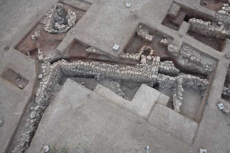
The south section of Wall B did not survive beyond the indentation. Another southbound wall was later built against the inner face of the indentation and in alignment with the western face of Wall B, thus blocking the indentation (and possibly a corridor or entrance connected with it), extending the southward course of the wall, and adjoining another westbound wall (D4-XCVII-42/51/52/62) (Figs 12, 17-20). This southbound wall survives to the height of only three courses and is undoubtedly a later addition, as it was founded on fill (partly cutting into the red fill) and displays a different wall construction. After these structures had gone out of use, they were subsequently filled in and overbuilt with houses during the Archaic period (7 th /6 th century BC), as attested by diagnostic finds (Corinthian roof tiles, Argive, Corinthian, and Athenian Black Figure pottery, Archaic figurines, clay loom weights and stamped clay spools, coins, lead weights and sheet, iron tools and nails, fragment of a clay water pipe) correlated with scarce wall remains that were founded high on the red fill above the earlier structures.
Wall B predates the Middle Geometric cist grave (late 9 th century BC) which abuts high on the eastern face of its indentation (D4-XCVII-42). The construction of this wall is dated to PG on diagnostic sherds retrieved from its foundation trench and from the joints of its western face. The wall suffered damages and partial destructions, but also underwent modifications and repairs during the Geometric period until it went finally out of use in the Archaic period. The combination of several variables, such as the surviving length, original thickness and height of the wall, the disintegration of its eastern face from erosion, and its wavy ground plan reflecting localized deformation, inclination, and structural stress from strong westward lateral thrust, all suggest a tentative identification of a strong retaining wall built to contain the red fill on its eastern side. The original function of that wall, however, could not have been to retain, given that the red fill on its eastern side had not yet been accumulated, when the wall was built (LH IIIC/PG), as attested by the absence of any cut or foundation trench within the red fill alongside the eastern face of the wall indentation (D4-XCVII-52). In that area (D4-XCVII-42/52) the red fill measures 1.5m in depth from the ground level of ca. 800 BC (defined by the Middle Geometric cist grave) down to the ground horizon of ca. 1100 BC (defined by the base of Wall B). The red fill, therefore, accumulated against the eastern face of the wall in a period of 300 years as a result of overflow and slope erosion which were partly caused by the gradual abandonment of the Mycenaean engineering projects in the post-Mycenaean era. Wall B, then, functioned inadvertently as a retaining wall (secondary use) and suffered structural stress and damages from the thrust of the red fill against its eastern face, thus requiring extensive and repeated repairs. The original function of the wall, however, still remains elusive: it may have served as an auxiliary outwork connected with the outer fortification wall of the Lower Town or as a barricade of the Protogeometric settlement, to judge from its relatively solid construction and size, the presence of an indentation, and the discovery of several arrow heads and sling stones in the vicinity of the wall. Wall B requires further investigation to securely define its form, function, chronology and modifications.
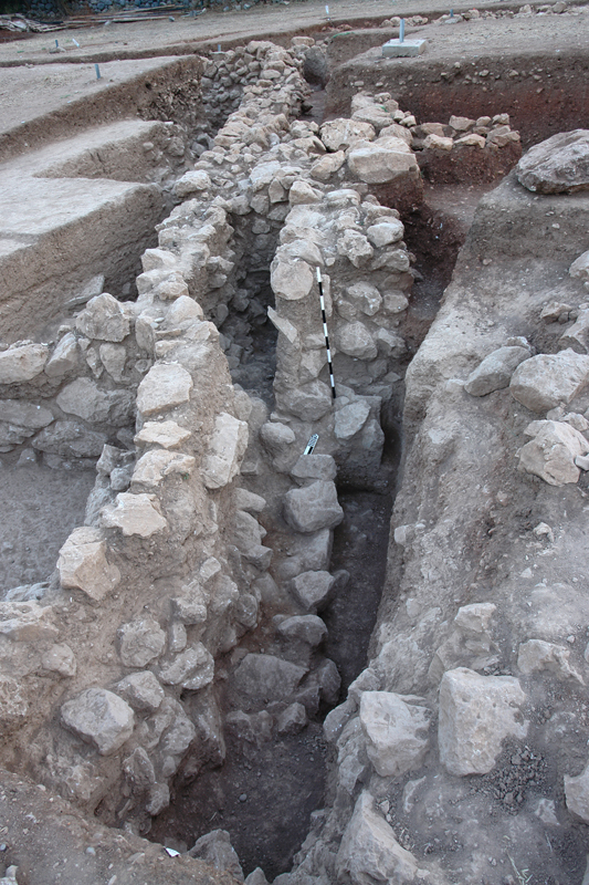
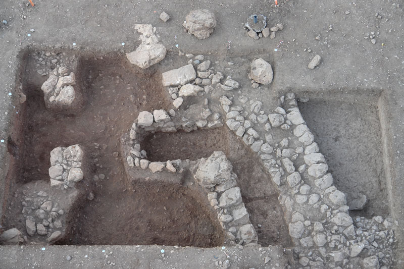
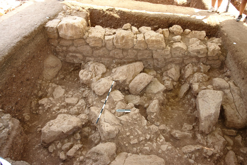
In the central sector of the excavated area (SWB II: D4-XCVII-43/53/63/73) a long Mycenaean wall (Wall A) was revealed. The wall runs N-S for 14.10m, matching its trace on the geoprospection images; it is thick (0.50-0.70m) and solid, buil t with boulders placed on the western façade and smaller field stones on its eastern face. The northern end of the wall preserves five superimposed courses to the height of 1.8m (D4-XCVII-43/53) by contrast with its much lower southern part ending with a cornerstone or anta which was surrounded by an ash layer with strong traces of fire (D4-XCVII-73). The wall was founded on the reddish-brown colluvial fill (water flow); its northern part is based on a foundation layer of packed cobbles and stone chips from the rough hewing of its boulders, whereas its southern part rests either on bedrock outcrops or upon boulders and stones deposited by the colluvial fill. The construction of Wall A is dated to LH IIIB on diagnostic sherds collected from the joints of its western façade and the northern end of its eastern face. The wall construction, building material, size, orientation, and great foundation depth below the stratigraphical horizon of the red fill (debris flow) collaborate the dating of the wall in the Mycenaean period. The original function of Wall A, however, still remains enigmatic. The correlation of this wall with the Chavos river or the adjacent torrent and its identification as a retaining wall is attractive, yet problematic: the wall does not appear to delineate the torrent riverbed, the solid and well-built face of the wall, its western façade, stands opposite to the water flow, and finally the fine red fill (debris flow) that gradually covered it had not yet been accumulated when the wall was built, as attested by the absence of any cut or foundation trench within the red fill alongside its eastern face. Wall A, on the other hand, is parallel, similar, and almost equal to an adjacent retaining wall of the terrace that bears the central gate and the northbound highway leading to the citadel, a correlation that may imply a similar function in connection with the fortification wall of the Lower Town. Further excavation is required to clarify the spatial arrangement of related structures and securely identify the original function of the Mycenaean wall.
Immediately beyond the north end of Wall A, two superimposed cobbled surfaces were uncovered (D4-XCVII-43/53). The upper cobbled surface (6.3m X 2m) rests partly upon the Mycenaean wall and stretches at the same level with several fragmentary cobbled layers (D4-XCVII-43/52/53/54/55/62/63/64/65) which apparently belong to the same stratigraphical and chronological horizon (destruction layer or eroded cobbled floors). The upper cobbled surface abuts on the foundations of the building complex of the central sector (houses and workshops) (D4-XCVII-53/54) and contained several Geometric sherds, including a few that belong to the same MG kantharos which dates both the cobbled surface and the building complex. The building complex of the central sector, the cobbled surfaces, and the Geometric cist grave belong to the same stratigraphical horizon, since they were founded upon or cut into the red fill (debris flow), and to the same chronological phase based on their pottery.
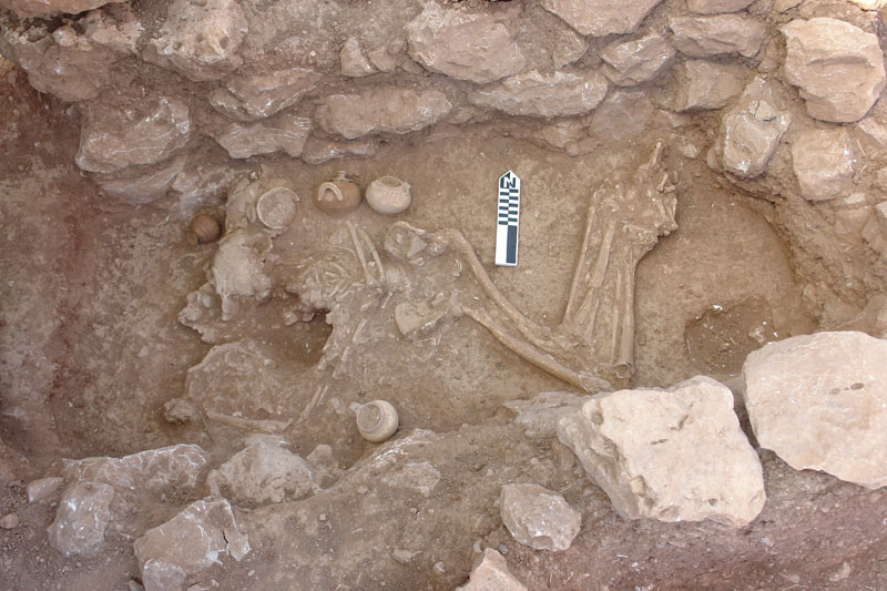
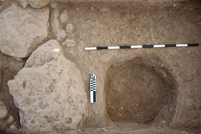
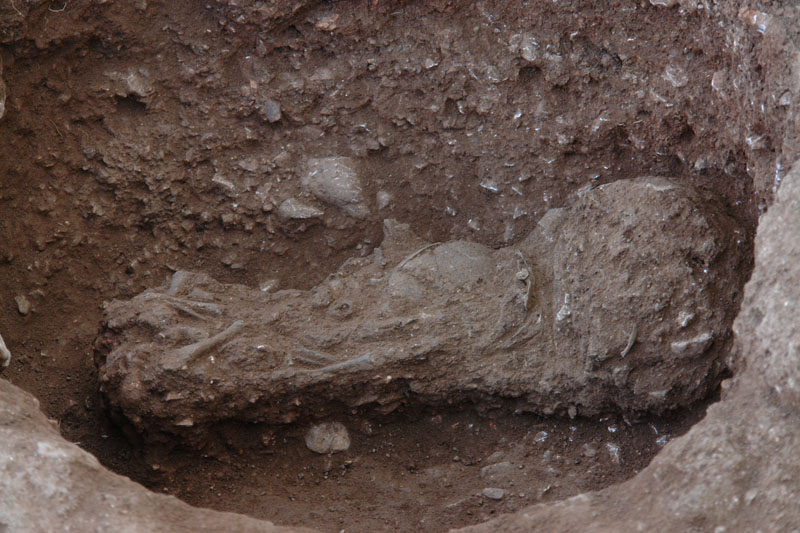
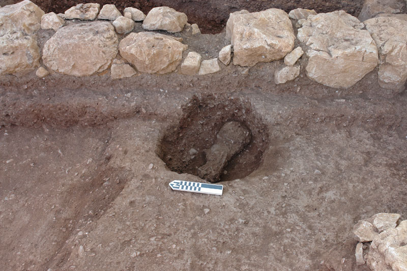
In the central sector a multi-room complex was discovered (D4-XCVII-54/55/64/65), consisting of at least three or four rooms which were founded upon the red fill with NW-SE orientation (Figs. 12, 18, 23, 29-32). The clay floors of these rooms, which are elevated by approximately 1m from the floors of the adjacent oblong building to the south, were found covered and sealed by a layer of cobbles, fallen stones, and roof tiles. The eastern rooms contained a shallow circular work pit and yielded figurines, a small bead, mixed pottery, and animal bones. The northernmost room was fully excavated (D4-XCVII-54) and produced two pit graves with children burials under the clay floor. The northern pit grave, which may have been originally covered with slabs (two of which were found vertically placed), contained the skeleton of an infant (1-2 years old). The child burial was furnished with four miniature faience beads of various colors and food (seed and organic remains and seed retrieved by flotation). The discovery of a small lump of plesia (insulating whitish mortar) from the clay floor inside the pit establishes that this pit grave postdates the construction of the floor, therefore being contemporary with the period of use of the overlying building. The eastern pit grave contained two infant skeletons (1-2 years old) and seed remains. The location of the pit abutting the foundation of the eastern wall of the room and the slightly raised placement of one of the skulls against it indicate that this pit follows and, therefore, postdates the wall, being contemporary with the period of use of the overlying building (Geometric).
To the south of this complex was uncovered an adjacent oblong building which had been detected by the geophysical survey in the southern part of the targeted sector (D4-XCVII-73/74/75). The oblong building is delineated by two long parallel walls running E-W for some 10m at a distance of 1.8m from each other. The solid northern wall (0.50-0.70m) is built with boulders placed on its southern face and smaller field stones on its northern face, whereas the parallel southern wall is of rather simpler and thinner construction (0.35m), being possibly a later addition to the building. Both walls were founded on a fill and survive to the height of two or three courses. The two long parallel walls and a thick partition wall abutting them at right angles define two adjoining rooms. The western corridor-like room (int. dim. 5.5m×1.8m) preserves parts of the clay floor and a shallow circular work pit coated with lime plaster (D4-XCVII-73/74). Ivory objects and animal bones were found near the partition wall in the eastern end of the western room. The eastern room (D4-XCVII-75) was later divided by a thin partition wall into two small chambers with clay floors. The discovery of joining sherds of the same pithos in both chambers or embedded in the south wall indicate damages, successive repairs and spatial rearrangement of the building with the addition of the partition wall. Several small finds were retrieved from the eastern part of the building, including sling stones, stone tools, a zoomorphic figurine, sherds of a large pithos, cookware (clay fry pans), and animal bones. The eastern part of the building incorporated an earlier circular structure, as revealed by careful examination of wall joints: the northern wall of the building abuts on the circular structure, while the severed southern part of the structure abuts on the southern wall of the building (D4-XCVII-75). The function of the circular structure, however, remains elusive (water cistern or clay basin?); to this end, an intact block soil sample consolidated with resin was collected from the interior of the structure for soil micromorphology. Further excavation is required to define the precise use and chronology of the oblong building, which yielded Mycenaean, Geometric, but also Early Archaic (Corinthian) pottery, and to elucidate its obscure spatial relationship, if any, with the long Mycenaean wall.
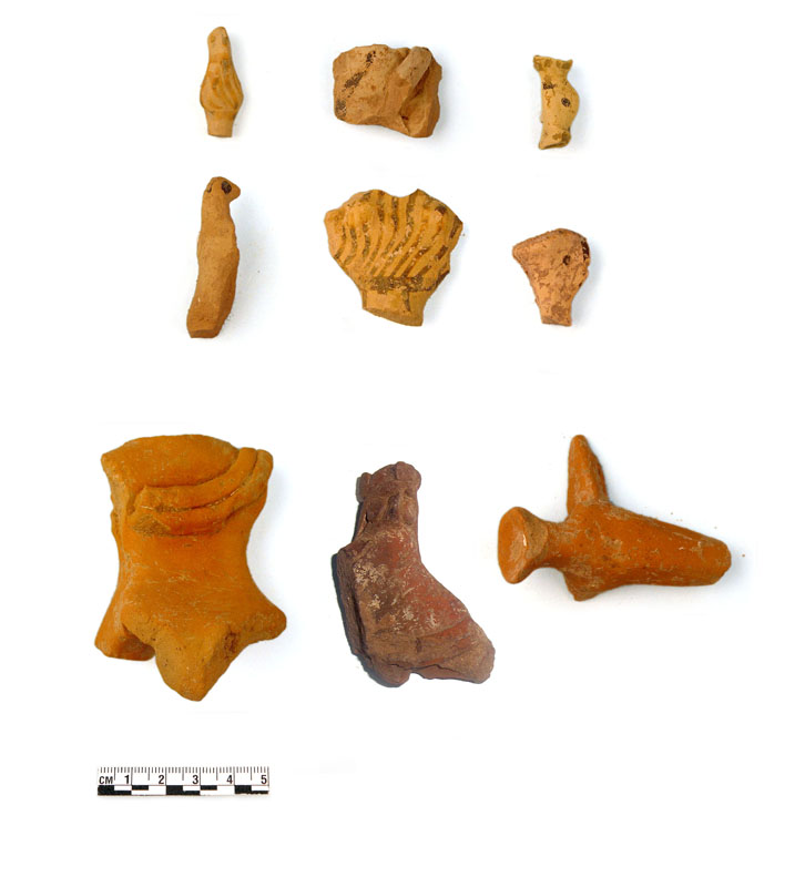
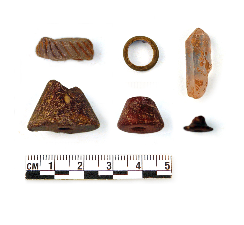
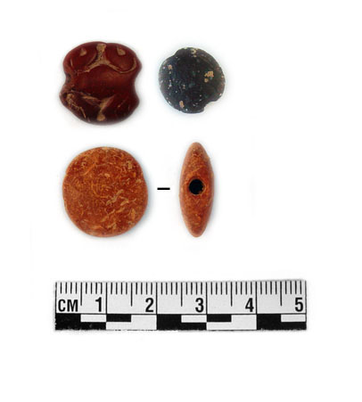
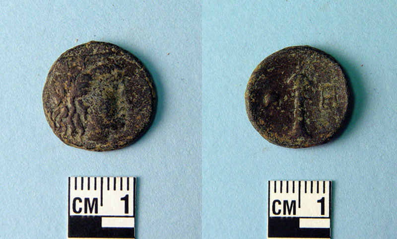
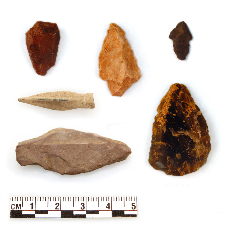
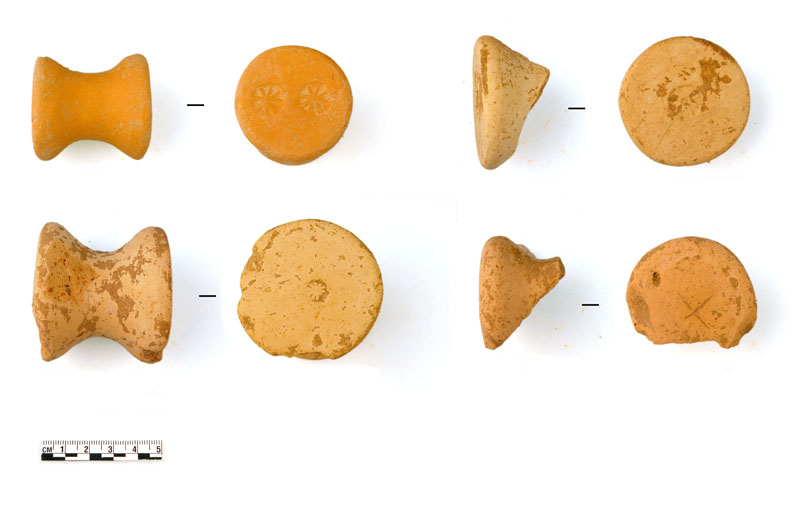
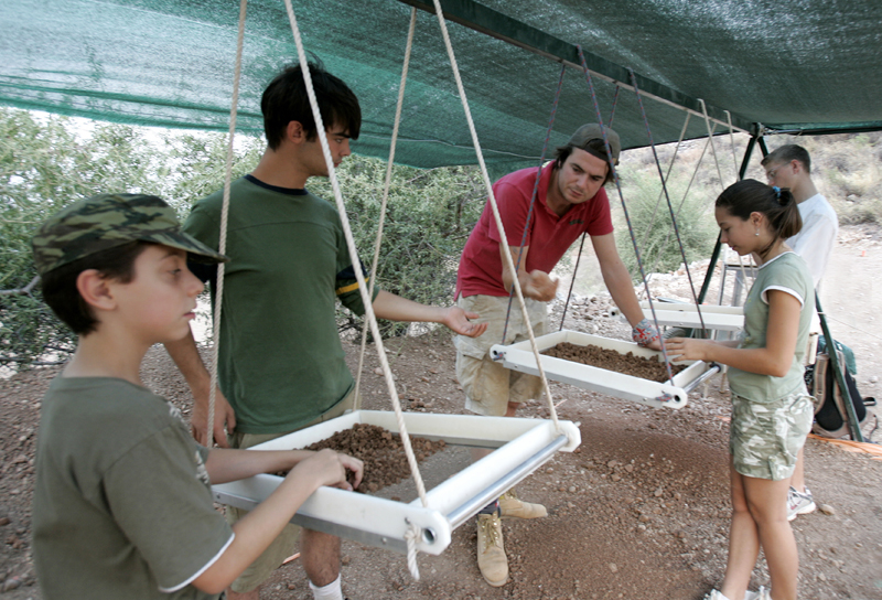
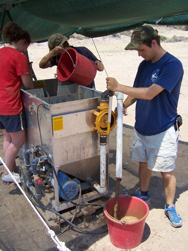
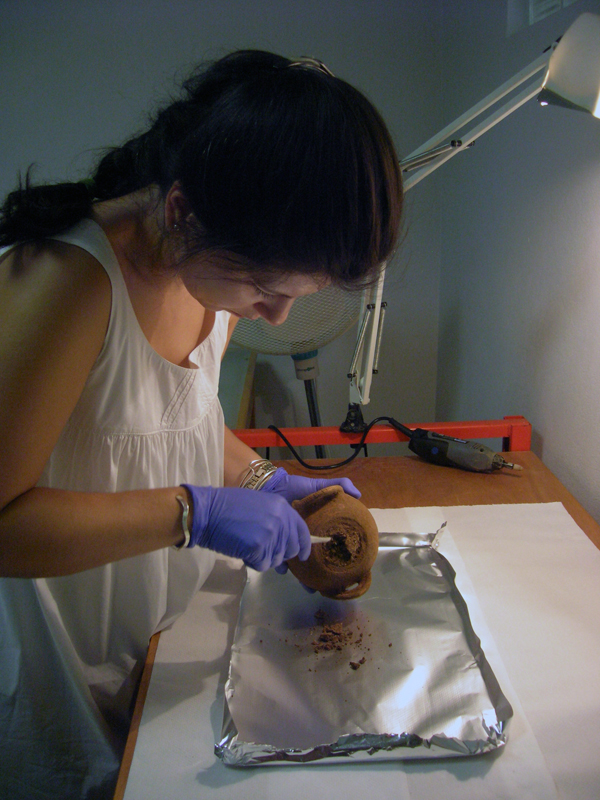
A great number and wide variety of finds were collected, including fragments of Mycenaean, Orientalizing and Archaic figurines; talisman pendants, jewelry (earrings, rings, pins), sealstones, and coins; ivory objects; fragments of stone vases and glass shards; arrowheads and sling stones; lead sheets and weights, lead repair clamps for pottery; flint and obsidian blades, flakes, and cores, grinders and stone tools; metallic objects and tools, iron nails and hooks, chisels and pointers; clay loom weights, spools, and clay stands; fresco and plaster fragments; color pigments, carbonized wood, animal bones, shell; roof tiles and abundant pottery (mainly Mycenaean, Geometric, and scarcely Geometric and Hellenistic). All excavated soil is sifted, and soil from uncontaminated closed contexts or undisturbed sealed layers is water-sieved (Flote-tech). Soil samples are systematically collected for soil micromorphology (intact block samples consolidated with resin) and archaeobotanical analysis (uncontaminated samples) which will hopefully contribute to a better understanding of the ancient landscape and its complex spatial organization. The preliminary study of the archaeobotanical material has identified remains of grape pips, olive stones, figs, cereal grains, barley, and pulses. The analysis of animal bones has identified a wide variety of domesticated animals (sheep, goats, cattle and pigs, dogs, donkey) and wild species (wild boar, deer, red deer , hare). All animals appear to be represented by all body parts, suggesting processing of complete carcasses on-site. Furthermore, human bones of newborn children were tentatively identified among the collected animal bones: these were found scattered in several contexts and are remains perhaps of disturbed children burials once interred under the floors or thresholds of houses which were eventually washed away by erosion. The preliminary examination of stone tools has generated interesting observations on manufacture techniques and use. Finally, the systematic classification and study of pottery is already underway (including collection of samples for thin-section petrographic and INAA analysis).
Field Research Aims
The short-term targets of the systematic investigation of the Lower Town at Mycenae involve exploration of the lay-out, borders and size of the settlement by geophysical survey, excavation of select prominent structures (megaron complex, buildings, roads, gates) to establish the topography, stratigraphy, chronology, and urban character of the settlement, immediate preservation and protection of the surveyed areas at this world heritage site. In the long run, the aim is to uncover arguably the most important Mycenaean urban center, which becomes even more imperative, given the lack or inaccessibility of the settlements at other mainland palatial sites. The systematic excavation of the Lower Town at Mycenae will certainly contribute to the study of Mycenaean domestic architecture and to a better understanding of Mycenaean town-planning, settlement development, urbanization, and interaction dynamics between settlement and palace. Fresh new evidence from the Lower Town will offer the opportunity to update, define or revise the local and regional ceramic sequence and further refine relative chronology; it may also further clarify the causes, extent, impact, dates of the destruction horizons at Mycenae, establish their correlation with similar catastrophes or partial destructions in the Argolid and extra-regional sites, and help assess their combined impact on the Mycenaean palatial states and the historical developments in the end of the Bronze Age (13th-12th centuries BC). The study and scientific analysis of portable finds and artifacts, anticipated in great quantity and variety, will shed new light on the socio-economic dynamics of the Mycenaean settlement, local workshops and crafts, production and storage, trade patterns and contacts. Soil micromorphology and systematic analysis of ecofacts will address a variety of palaeoenvironmental, archaeozoological and archaeobotanical issues and elucidate aspects of ancient economy and landscape.


